![]()
New release of 300 m global land cover and 150 m water products (v.1.6.1) and new version of the User Tool (3.10) for download
Submitted by abellavia on Thu, 2016-01-28 22:00On behalf of the ESA Land Cover consortium, it is our pleasure to inform you about the release of a new version of the ESA CCI Land Cover dataset (v 1.6.1) as well as a new version of the ESA CCI Land Cover User Tool (v.3.10), both available for download from http://maps.elie.ucl.ac.be/CCI/viewer/.
The Urban Round Robin is launched !
Submitted by abellavia on Sun, 2015-10-18 15:53Through the ESA Climate Change Initiative, a dozen of essential climate variables have been addressed to meet the needs of the climate modeling community. Land cover is one of these priority variables and a first version of 300m global land cover maps is already available. Read more »
First official release of a new generation of satellite-derived global land cover products
Submitted by Anonymous on Wed, 2014-10-01 14:38The CCI Land Cover (LC) team is proud to announce the release of its 5 key products to its climate and LC communities: Read more »
CCI Land Cover: launch of Phase 2
Submitted by Anonymous on Fri, 2014-04-04 12:56The Land Cover CCI consortium is pleased to announce that ESA has decided to continue the work on global land cover map development for climate modeling applications with the current CCI consortium. One additional partner has yet joind the team: University of Pavia. UPavia will collaborate with UJena on the development of specific algorithms for urban area detection at the global scale.
This new project phase (Phase 2) officially kicked-off on February 1 and will last for a period of 36 months. The project aims at capitalizing the results of Phase 1. Read more »
Successful Final Review Meeting for Phase 1
Submitted by Anonymous on Fri, 2014-04-04 12:06The Land Cover Consortium held a successful final Review Meeting on Dec 05-06, 2013 in ESRIN, during which the major findings and achievements of this project were presented and thoroughly discussed. Though the total project length took longer than anticipated (42 months instead of 36 months), the consortium reached its targets by completing the development and validation of the following products: Read more »
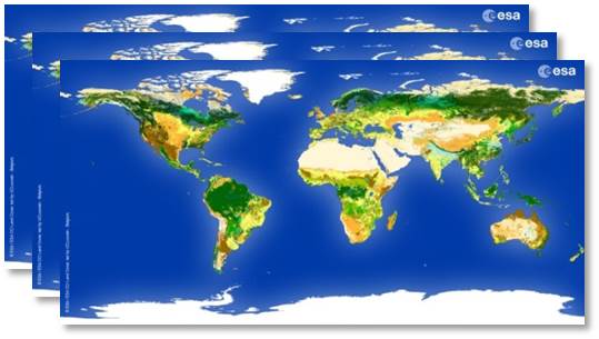
Successful development and internal release of three global land cover maps with 300m resolution
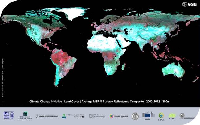
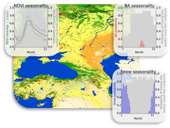
Submitted by Anonymous on Tue, 2013-05-28 15:04The CCI Land Cover (LC) team is proud to announce the successful development of three new global land cover databases at 300m resolution, which consist of LC state products for three epochs – centred around 2000, 2005 and 2010 – and of LC condition (snow, NDVI and burnt areas) products. The global surface reflectance (SR) composite time series for the period 1998-2012, which serve as input for generating the global land cover databases, are also an output of the CCI LC project. Read more »
Internal release of global land cover map with improved accuracy over the existing state of the art (75.6%)
Submitted by Anonymous on Fri, 2013-01-11 07:50The CCI Land Cover team has now successfully released its first global land cover map (V1.0) with improved accuracy over the existing state of the art (75.6%). This map covers the 2008-2012 epoch and will be updated (V1.1) by the end of the project (October 2013). It will be delivered along with two other maps covering the 1998-2002 and 2003-2007 periods to form a three-epoch series. Read more »
Land_Cover_cci : Recent progresses and status.
Submitted by Anonymous on Wed, 2012-08-01 07:25In this section we report on the current status and recent progress realized in the framework of the Land_Cover_cci project.
After complete acquisition of SPOT VGT, MERIS RR and MERIS FR surface reflectance data as well as Wide swath ASAR data, the 2008-2012 MERIS FR and RR 7-day composites were pre-processed by Brockmann Consult and provided to UCL. Read more »
The Land_Cover_cci project is now officially into Phase 2
Submitted by Anonymous on Mon, 2012-01-23 22:25By closing the round robin activity and delivering all required documents, the Land_Cover_cci consortium ended Phase 1 and has now officially entered into Phase 2. To recall, the timeline of this three-year long project is divided into three distinct phases, each corresponding to specific activities in the development cycle of the land cover product prototype : Read more »
November 2011 - 3rd Newsletter of the Land_Cover_cci project
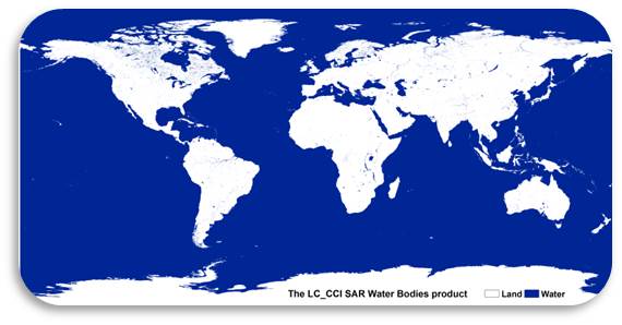
Submitted by Anonymous on Tue, 2011-11-29 22:37The 3rd Newsletter of the Land_cover_cci consortium is now available. It summarizes key results achieved during the project Phase 1, discloses the preparation of an ENVISAT ASAR data-based global water body product, and informs on preliminary results from the Round Robin. The Round Robin is now officially closed. Read more »
CCI Land Cover products